The best handheld GPS devices for backpacking help you follow routes accurately, monitor your position, and stay oriented when trails become unclear or cellular coverage disappears. The right model depends on whether you prioritize simple navigation, detailed mapping, long battery life, or two-way satellite communication.
We selected 10 rugged Garmin devices spanning compact eTrex navigators, feature-rich GPSMAP units, Montana models, and inReach communicators. Use the guide below to compare their key differences and choose the right balance of capability, durability, and price for your trips.
Best 10 Handheld Gps Devices for Backpacking Picks for 2026
Best Connected Navigator
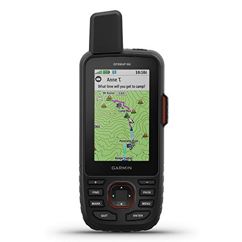
- Satellite messaging, SOS, and weather support
- Preloaded topo maps with Birdseye imagery access
- Up to 200 hours in Expedition mode
Best For: Remote backpackers needing navigation and off-grid communication
Best Large-Screen Touchscreen

- Bright 4-inch touchscreen display
- Preloaded U.S. Topo maps with shaded relief
- Compass, altimeter, and geotagging camera
Best For: Users who prefer a large display and touchscreen controls
Best for Challenging Terrain

- Multi-band and expanded GNSS support
- Button-operated 2.6-inch color display
- Compass, altimeter, and TopoActive maps
Best For: Navigation in forests, steep terrain, and difficult signal environments
Best Value Battery Life

- Up to 25 hours on two AA batteries
- Lightweight 4.96-ounce design
- Routable TopoActive maps and GPS/GLONASS
Best For: Simple, lightweight navigation with replaceable batteries
Best Connected Safety Pick

- Two-way satellite messaging and SOS
- Compact 99-gram design
- Up to 14 days in tracking mode
Best For: Remote backpackers who need communication beyond cell service
Best Long-Battery Mapping Value

- Preloaded routable TopoActive maps
- Up to 25 hours on two AA batteries
- Three-axis compass and barometric altimeter
Best For: Extended trips where battery life and basic mapping matter
Best Accuracy in Difficult Terrain

- Multi-band and expanded GNSS support
- 2.6-inch sunlight-readable color display
- Routable maps and U.S. public land boundaries
Best For: Backpackers navigating forests, steep terrain, and urban canyons
Best Battery Life

- Up to 1,800 hours in expedition mode
- Sunlight-readable 2.2-inch display
- Multi-GNSS and IPX7 water resistance
Best For: Long backpacking trips with limited charging access
Best Rugged Floating Design

- Floating, rugged body with IPX6 water resistance
- Worldwide basemap and multi-constellation tracking
- Compass and barometric altimeter included
Best For: Wet-weather routes and backcountry travel near water
Best Large-Screen Navigator

- 5-inch glove-friendly touchscreen
- TopoActive maps and 32 GB storage
- Rugged MIL-STD 810 and IPX7-rated design
Best For: Detailed map viewing and feature-rich backcountry navigation
Best Connected Navigator – Garmin GPSMAP 66i
For backpackers who want navigation plus off-grid communication, the Garmin GPSMAP 66i is one of the most capable handheld GPS devices for backpacking. It combines a sunlight-readable color display, preloaded topographic maps, multi-GNSS support, and inReach satellite messaging and SOS features, though satellite communication requires a subscription.
Best For: Remote backpackers who want navigation, two-way satellite messaging, interactive SOS, and weather access in one device.
Pros:
- Two-way messaging and interactive SOS through the global Iridium satellite network
- Preloaded TOPO maps with Birdseye satellite imagery downloads available without an annual subscription
- 3-inch sunlight-readable display, multi-GNSS support, and navigation sensors
- Up to 200 hours in Expedition mode
Cons:
- Satellite messaging and SOS require a subscription
- More features and cost than needed for basic navigation
- Satellite-device regulations may apply in some jurisdictions
The 66i is a strong choice when communication and emergency coverage matter as much as route finding. Its mapping and tracking tools are well suited to extended trips, while the subscription requirement is the main ongoing consideration.
Best Large-Screen Touchscreen – Garmin Montana 650t
The Garmin Montana 650t is a large, touchscreen-oriented option among handheld GPS devices for backpacking. Its 4-inch sunlight-readable display, U.S. Topo maps, compass, barometric altimeter, and camera make it useful for users who prefer a broad visual interface and extra field features.
Best For: Hikers and outdoor users who prioritize a large touchscreen, built-in U.S. Topo maps, and camera functionality.
Pros:
- Bright 4-inch sunlight-readable color touchscreen
- Includes a 3-axis compass and barometric altimeter
- Preloaded U.S. Topo maps with shaded relief
- 5-megapixel autofocus camera with automatic geotagging
Cons:
- Heavier than the other listed handhelds at 16 ounces
- Battery life is listed at up to 16 hours
- Its model year is 2011, so it may feel dated compared with newer units
The Montana 650t makes the most sense for backpackers who value screen size and touch control over minimal weight. Its older design and heavier body are trade-offs for the roomy display and built-in camera.
Best for Challenging Terrain – Garmin GPSMAP 65s
The Garmin GPSMAP 65s is designed for accurate positioning in difficult environments, making it a compelling choice among handheld GPS devices for backpacking. Multi-band technology and expanded GNSS support are intended to improve accuracy in forests, steep terrain, and urban canyons, while the button-operated design remains practical outdoors.
Best For: Backpackers navigating dense forests, steep country, or other areas where improved satellite accuracy is important.
Pros:
- Multi-band technology and expanded GNSS support for challenging locations
- 2.6-inch sunlight-readable color display
- Includes a 3-axis compass and barometric altimeter
- Preloaded TopoActive maps and U.S. public land boundaries
Cons:
- Does not include built-in satellite messaging or SOS
- Button controls may be less intuitive than a touchscreen
- Battery life is listed at up to 16 hours
The 65s is a focused navigation tool for backpackers who care about positioning performance more than communications features. Its durable button interface, sensors, and multi-band support make it especially appealing for complex terrain and tree cover.
Best Value Battery Life – Garmin eTrex 22x
The Garmin eTrex 22x is a straightforward, lightweight option for backpackers who want dependable route guidance without extra communication features. It offers a 2.2-inch sunlight-readable color display, routable TopoActive maps, GPS and GLONASS support, and up to 25 hours of battery life from two AA batteries.
Best For: Budget-conscious backpackers who want simple navigation, replaceable batteries, and long runtime.
Pros:
- Up to 25 hours of battery life with two AA batteries
- Lightweight 4.96-ounce handheld design
- Preloaded TopoActive maps with routable roads and trails
- Supports GPS and GLONASS for tracking in challenging environments
Cons:
- Smaller 2.2-inch display than the other listed models
- No touchscreen or satellite communication features
- Limited to 8 GB of internal memory, though it has a microSD slot
The eTrex 22x is a sensible pick for basic hiking and backpacking navigation, particularly when easy-to-replace AA batteries are valuable. It gives up advanced sensors, messaging, and screen size in exchange for a lighter and simpler package.
Best Connected Safety Pick – Garmin inReach Mini 2
For backpackers who want more than basic positioning, the Garmin inReach Mini 2 combines navigation tools with two-way satellite messaging and SOS capability. Its compact, 99-gram design makes it a practical choice among handheld GPS devices for backpacking, but an active satellite subscription is required for messaging, location sharing, and SOS features.
Best For: Backpackers who prioritize emergency communication and location sharing beyond cell coverage.
Pros:
- Two-way messaging and interactive SOS available globally with an active subscription
- Compact, lightweight design with up to 14 days of battery life in 10-minute tracking mode
- Digital compass, TracBack routing, and Garmin Explore app compatibility
Cons:
- Messaging, SOS, and location-sharing features require an active satellite subscription
- Its 1.27-inch monochrome display is smaller and less map-focused than dedicated color GPS units
- Satellite communication devices may be regulated or prohibited in some jurisdictions
The inReach Mini 2 is best viewed as a satellite communicator with useful navigation features rather than a full-size mapping GPS. Choose it when reliable contact and emergency support matter most on remote trips.
Best Long-Battery Mapping Value – Garmin eTrex 32x
The Garmin eTrex 32x is a straightforward, rugged navigator for hikers who want color maps, trail routing, and dependable battery life. With preloaded TopoActive maps, GPS and GLONASS support, and expandable storage, it is a strong practical option among handheld GPS devices for backpacking.
Best For: Backpackers seeking a durable, map-capable GPS with long runtime and simple replaceable batteries.
Pros:
- 2.2-inch sunlight-readable color display with preloaded routable TopoActive maps
- Up to 25 hours of GPS use from two AA batteries
- 8 GB of internal memory plus a microSD card slot for additional maps
- Three-axis compass and barometric altimeter add useful outdoor data
Cons:
- Smaller display than the GPSMAP 65
- Touchscreen and control specifications may be less intuitive than a modern smartphone-style interface
- No satellite messaging or SOS communication feature is listed
The eTrex 32x favors practical navigation over connected features. Its long battery life, AA power source, and built-in maps make it well suited to extended trips where charging opportunities are limited.
Best Accuracy in Difficult Terrain – Garmin GPSMAP 65
The Garmin GPSMAP 65 is designed for backpackers who regularly navigate under dense tree cover, in steep terrain, or around urban canyons. Its expanded GNSS support and multi-band technology aim to improve positioning accuracy, while the 2.6-inch color screen and button controls keep field operation practical.
Best For: Hikers who need accurate positioning in challenging environments and prefer physical buttons.
Pros:
- Multi-band technology and expanded GNSS support for difficult signal conditions
- Large 2.6-inch sunlight-readable color display
- Includes routable TopoActive maps and U.S. federal public land boundaries
- Works with Garmin Explore for managing tracks, routes, and waypoints
Cons:
- Battery life is rated at up to 16 hours, shorter than the eTrex 32x
- Does not list satellite messaging or SOS communication
- Public land map coverage is specified for the U.S. only
The GPSMAP 65 is the most accuracy-focused option in this group. It makes the most sense when reliable positioning in forests, steep country, or built-up areas is more important than maximum battery runtime or satellite communication.
Best Battery Life – Garmin eTrex SE
For backpackers who prioritize long stretches between battery changes, the Garmin eTrex SE is a compact choice among handheld GPS devices for backpacking. Its sunlight-readable display, multi-GNSS support and button controls make it practical for route checking in varied outdoor conditions.
Best For: Backpackers seeking exceptional battery life and a lightweight, straightforward navigator.
Pros:
- Up to 168 hours in standard mode or 1,800 hours in expedition mode
- Multi-GNSS support includes GPS, GLONASS, Galileo, BeiDou and QZSS
- 2.2-inch high-resolution display is designed for bright sunlight
- IPX7 water-resistant design and digital compass work well for trail use
Cons:
- Two field-replaceable AA batteries are required and are not included
- Small display and button controls may feel less convenient than a touchscreen
- Additional app features require pairing with a compatible smartphone
The eTrex SE stands out for battery endurance and portability. It is a particularly sensible pick for extended trips where charging access is limited, though its compact screen favors simple navigation over detailed map viewing.
Best Rugged Floating Design – Garmin GPSMAP 79s
Garmin GPSMAP 79s, Marine GPS Handheld with Worldwide Basemap, Rugged Design and Floats in Water
Check Price On AmazonThe Garmin GPSMAP 79s is a rugged option for backpackers who may encounter wet conditions or water crossings. It combines a floating, water-resistant body with worldwide basemap coverage, multiple satellite constellations and sensors useful for reading elevation and direction.
Best For: Wet-weather backpacking, backcountry travel near water and users who want a durable button-operated GPS.
Pros:
- Rugged design floats in water and has IPX6 water resistance
- Supports GPS, GLONASS, BeiDou, Galileo, QZSS and SBAS
- Stores up to 10,000 waypoints, 250 routes and 300 fit activities
- Includes a 3-axis compass and barometric altimeter
Cons:
- Battery life is up to 20 hours in GPS mode
- The listed display resolution is 240 x 400, less detailed than some larger navigators
- Its floating, rugged design weighs about 282 grams
The GPSMAP 79s is a strong durability-focused choice, especially for trips involving rain, rivers or boating. Its shorter battery runtime and heavier build make it less appealing for ultralight backpackers focused strictly on pack weight.
Best Large-Screen Navigator – Garmin Montana 710
With its 5-inch glove-friendly touchscreen and included TopoActive maps, the Garmin Montana 710 is built for backpackers who prefer a large, highly visible interface. It also adds satellite imagery support, substantial storage and ABC sensors for more detailed trip planning and navigation.
Best For: Backpackers who want a large touchscreen, extensive mapping capacity and versatile navigation features.
Pros:
- Large 5-inch touchscreen is designed for easy viewing and glove use
- Includes TopoActive maps and supports additional map downloads
- 32 GB of storage accommodates maps and expedition data
- Rugged MIL-STD 810 construction with IPX7 water resistance
Cons:
- At 14.5 ounces, it is substantially heavier than compact handheld units
- GPS battery life is up to 24 hours, while additional mapping content may require separate purchases
- Mounting options and premium Outdoor Maps+ content are sold separately
The Montana 710 offers the clearest, most feature-rich navigation experience of these handheld GPS devices for backpacking. Its larger size and weight are the trade-offs for easier map reading, expanded storage and support for satellite imagery.
How We Picked the Best Handheld Gps Devices for Backpacking
We focused on devices suited to extended outdoor use rather than casual phone-based navigation. Our evaluation considered satellite reception, mapping support, battery performance, screen or button usability, weather resistance, durability, and the practical value of features such as an electronic compass, barometric altimeter, wireless connectivity, and satellite messaging.
The lineup includes both traditional GPS navigators and communication-focused devices. That distinction matters: a satellite communicator can send messages and SOS alerts, but it may not provide the same large-screen mapping experience as a dedicated navigator.
Quick Comparison
| Best For | Recommended Type | What to Look For |
|---|---|---|
| Simple route tracking | Compact eTrex navigator | Long battery life, waypoint support, readable display |
| Challenging terrain | GPSMAP 65 or 65s | Multi-band reception, expanded satellite support, compass and altimeter |
| Messaging and emergencies | inReach device | Satellite plans, two-way messaging, SOS capability |
| Large-screen mapping | Montana navigator | Touchscreen size, detailed maps, higher power demands |
| Water-based trips | GPSMAP 79s | Floating design, marine features, waterproof construction |
Key Buying Factors for Handheld Gps Devices for Backpacking
Reception and Satellite Support
Modern multi-band models can maintain a more dependable position in canyons, dense forests, and areas with reflected signals. For ordinary open-trail hiking, a standard GPS receiver may be sufficient; for difficult terrain, expanded satellite support and multi-band technology are worthwhile upgrades.
Maps, Screen, and Controls
Check whether the device includes usable topographic maps or requires an additional purchase. A larger color screen makes route planning easier but generally increases size and battery consumption. Button-operated units are often easier to use with gloves, while touchscreens can be faster for browsing maps in good conditions.
Battery Life and Charging
Consider the longest section of your trip, not just a typical day hike. Replaceable batteries are convenient for remote travel, while rechargeable models reduce packing complexity. Always account for cold temperatures, frequent screen use, tracking intervals, and wireless communication, all of which can shorten runtime.
Safety and Communication
If you travel beyond reliable cellular coverage, an inReach communicator adds two-way messaging and emergency contact features, typically through a subscription plan. A GPS-only navigator can help you find your position but cannot independently send an SOS or communicate with rescuers.
Who Should Buy Which Handheld Gps Devices for Backpacking?
Choose an eTrex model if you want a compact, straightforward navigator for established routes and occasional backcountry trips. Choose the GPSMAP 65 or 65s when reception reliability, physical controls, and navigation sensors matter most. The 66i or inReach Mini 2 is a better fit for solo travelers and anyone who needs off-grid communication, with the 66i offering a more navigation-focused handheld format.
Pick a Montana model if detailed maps and a large display outweigh concerns about bulk and battery use. The GPSMAP 79s is especially practical for paddlers, boaters, and wet environments because it floats. Before buying, confirm map coverage for your destination, estimate your battery needs, and determine whether a satellite subscription is necessary for your safety plan.