The best handheld GPS devices with topo maps make it easier to follow trails, record routes, and navigate confidently when cell service disappears. The right model depends on whether you prioritize detailed mapping, satellite messaging, rugged simplicity, or a large glove-friendly display.
Our roundup covers compact eTrex navigators, advanced GPSMAP units, inReach communicators, and larger Montana-style devices so you can match features and cost to your usual adventures.
Best 10 Handheld Gps Devices with Topo Maps Picks for 2026
Satellite Safety Navigator
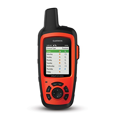
- Two-way Iridium messaging and interactive SOS
- Preloaded topo maps with GPS routing
- 30-hour rechargeable battery and IPX7 rating
Best For: Remote trips requiring navigation and satellite communication
High-Accuracy Trail Navigator

- Multi-band GNSS for difficult environments
- Routable TopoActive maps included
- Compass, altimeter, and sunlight-readable display
Best For: Hiking, hunting, and navigation in challenging terrain
Simple Trail Mapping Value

- Routable TopoActive roads and trails
- Up to 25 hours on two AA batteries
- 8 GB storage plus microSD expansion
Best For: Straightforward hiking and cycling navigation
Connected Expedition Navigator
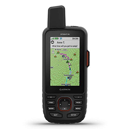
- TOPO maps plus Birdseye satellite imagery downloads
- InReach messaging and interactive SOS
- Up to 200 hours in Expedition mode
Best For: Extended backcountry trips needing mapping and satellite safety
Trail-Ready Mapping

- Preloaded routable TopoActive maps
- GPS and GLONASS support
- Compass, altimeter, and 25-hour battery life
Best For: Hikers and cyclists needing compact topo navigation
High-Accuracy Navigation

- Multi-band and expanded GNSS support
- Routable topo and U.S. public-land maps
- 2.6-inch sunlight-readable display
Best For: Outdoor navigation in forests, steep terrain, and urban canyons
Long-Life Exploration

- Up to 168 hours standard or 1,800 hours expedition mode
- Multi-GNSS support and digital compass
- IPX7 water resistance with Garmin Explore pairing
Best For: Extended hikes, backpacking, and geocaching
Trail-Ready Classic

- Preloaded TopoActive maps with routable roads and trails
- Multi-GNSS receiver with compass and barometric altimeter
- Rugged button-operated design with 16-hour battery life
Best For: Hikers and cyclists who prefer physical controls
Long-Life Navigator
NiesahYan Handheld GPS with USA Topo Maps

- USA Topo maps with 32 GB internal storage
- Up to 36 hours of rechargeable battery life
- 3.2-inch sunlight-readable screen and IP66 water resistance
Best For: Hikers and campers seeking extended battery life
Connected Expedition Tool
Garmin Montana 750i with inReach

- 5-inch touchscreen with preloaded TopoActive and City Navigator maps
- Built-in inReach messaging and SOS require a subscription
- Rugged design with camera, compass, and barometric altimeter
Best For: Backcountry travelers needing navigation and satellite communication
Satellite Safety Navigator – inReach Explorer+
The Garmin inReach Explorer+ stands out among handheld GPS devices with topo maps because it combines navigation with two-way satellite communication. Its preloaded North America maps, GPS routing, and 30-hour rechargeable battery make it a practical choice for remote trips, while an active satellite subscription is required for messaging and SOS features.
Best For: Remote hikers and travelers who want topo-map navigation plus satellite messaging and emergency support.
Pros:
- Two-way text messaging and interactive SOS over the global Iridium satellite network
- Preloaded DeLorme topo maps with on-screen GPS routing
- Built-in digital compass, barometric altimeter, and accelerometer
- Up to 30 hours of battery life and IPX7 water resistance
Cons:
- Satellite messaging and SOS features require a subscription
- Small 2.3-inch display with button controls
- Designed around North America map coverage in the supplied specifications
The Explorer+ is more than a conventional GPS: it is a communication and safety device with useful topo navigation. Choose it when off-grid contact is as important as mapping.
High-Accuracy Trail Navigator – GPSMAP 65s
The Garmin GPSMAP 65s is a strong option among handheld GPS devices with topo maps for challenging terrain. Its multi-band technology and expanded GNSS support are designed to improve accuracy in forests, steep country, and urban canyons, while routable TopoActive maps support everyday trail navigation.
Best For: Hikers, hunters, and geocachers who prioritize positioning accuracy and durable button-based navigation.
Pros:
- Multi-band GNSS technology and expanded satellite-system support
- Preloaded routable TopoActive maps and U.S. federal public land boundaries
- 2.6-inch sunlight-readable color display
- Three-axis compass and barometric altimeter provide useful field data
Cons:
- Battery life is listed at up to 16 hours
- Requires a compatible smartphone for Garmin Explore app features
- Does not include satellite messaging or SOS service in the supplied features
The GPSMAP 65s is the most accuracy-focused pick in this group. It makes sense for users who need reliable positioning under difficult signal conditions without adding satellite communication costs.
Simple Trail Mapping Value – eTrex 22x
The Garmin eTrex 22x is a straightforward choice for shoppers seeking handheld GPS devices with topo maps at a lighter, simpler format. It includes a 2.2-inch color screen, routable TopoActive maps, GPS and GLONASS support, and storage for additional map downloads through internal memory and a microSD card slot.
Best For: Hikers, cyclists, and outdoor users who want basic topo navigation with long battery life and replaceable AA batteries.
Pros:
- Preloaded TopoActive maps include routable roads and trails
- GPS and GLONASS support can help in challenging environments
- Up to 25 hours of battery life with two AA batteries
- 8 GB of internal memory plus a microSD card slot
Cons:
- Smaller 2.2-inch display than the GPSMAP models
- No touchscreen and no satellite communication features listed
- Bluetooth is listed, but advanced connected features are limited in the supplied details
The eTrex 22x favors dependable basics over advanced sensors or communications. It is a sensible pick when you want routable topo maps, expandable storage, and replaceable batteries without a more complex feature set.
Connected Expedition Navigator – GPSMAP 66i
The renewed Garmin GPSMAP 66i combines handheld GPS devices with topo maps and satellite communication in one expedition-oriented unit. It includes a large 3-inch display, TOPO mapping, satellite imagery downloads, global GNSS support, and inReach messaging and SOS capabilities, although satellite communication requires a subscription.
Best For: Backcountry users who want large-screen mapping, satellite safety features, and extended tracking battery modes.
Pros:
- Two-way satellite messaging and interactive SOS through inReach technology
- Preloaded TOPO mapping with direct-to-device Birdseye satellite imagery downloads
- Large 3-inch sunlight-readable color display
- Up to 35 hours in tracking mode and up to 200 hours in Expedition mode
Cons:
- Satellite messaging and SOS require a subscription
- This is a renewed product with a listed 90-day limited warranty
- Cellular connectivity and weather features depend on applicable connectivity and service
The GPSMAP 66i is the most capable all-in-one option here for extended off-grid travel. Its renewed status and subscription requirement are important trade-offs, but the larger display, mapping, and communication tools make it well suited to expeditions.
Trail-Ready Mapping – Garmin eTrex 32x
The Garmin eTrex 32x is a practical choice for shoppers seeking handheld GPS devices with topo maps for hiking, cycling, and general outdoor navigation. Its sunlight-readable color screen, routable TopoActive maps, and support for both GPS and GLONASS provide useful navigation features in a compact, rugged design.
Best For: Hikers and cyclists who want preloaded topo maps, expandable storage, and a built-in compass and barometric altimeter.
Pros:
- Preloaded TopoActive maps include routable roads and trails.
- GPS and GLONASS support can improve tracking in challenging environments.
- Includes a 3-axis compass and barometric altimeter.
- Up to 25 hours of battery life with two AA batteries.
Cons:
- The 2.2-inch display is relatively small.
- Touchscreen controls may be less convenient than dedicated buttons in some outdoor conditions.
- Additional microSD map storage may be needed for extensive downloads.
The eTrex 32x balances essential topo mapping and outdoor sensors with long battery life and a lightweight body. It is a solid fit when straightforward navigation matters more than a large screen or advanced wireless features.
High-Accuracy Navigation – Garmin GPSMAP 65
The Garmin GPSMAP 65 is designed for demanding routes where reception can be difficult. Among handheld GPS devices with topo maps, it stands out for expanded GNSS support and multi-band technology, along with a larger 2.6-inch sunlight-readable display and routable TopoActive mapping.
Best For: Hikers, campers, and hunters navigating steep terrain, dense forests, or urban canyons who prioritize positioning accuracy.
Pros:
- Multi-band technology and expanded GNSS support help maintain accuracy in challenging locations.
- Includes routable TopoActive maps and U.S. federal public land mapping.
- The 2.6-inch sunlight-readable display is larger than the screens on the other listed models.
- Works with Garmin Explore for managing tracks, routes, and waypoints.
Cons:
- Battery life is rated at up to 16 hours, shorter than the other listed options.
- Garmin Explore features require a compatible smartphone.
- Button controls may feel less familiar to users accustomed to touchscreens.
Choose the GPSMAP 65 when reception reliability is a priority. Its advanced satellite support and public-land mapping make it especially useful for complex terrain, though its shorter battery rating and smartphone-dependent app features are worth considering.
Long-Life Exploration – Garmin eTrex SE
The Garmin eTrex SE is a lightweight option for shoppers comparing handheld GPS devices with topo maps and prioritizing battery endurance. Its sunlight-readable display, multi-GNSS support, digital compass, and wireless connection to Garmin Explore make it suited to extended hikes and trips.
Best For: Backpackers and geocachers who want exceptionally long battery life, wireless updates, and a weather-resistant handheld navigator.
Pros:
- Runs for up to 168 hours in standard mode or 1,800 hours in expedition mode.
- Uses multiple GNSS systems, including GPS, GLONASS, Galileo, BeiDou, and QZSS.
- Garmin Explore pairing enables wireless updates, trip planning, and additional mapping.
- IPX7 water resistance and a compass that works while stationary support outdoor use.
Cons:
- Two AA batteries are required and are not included.
- Additional mapping and smart features depend on pairing with a compatible smartphone.
- The 2.2-inch screen is compact.
The eTrex SE is the strongest choice here for minimizing battery changes. It offers broad satellite compatibility and useful app-connected features, but shoppers should account for the need to supply batteries and use a smartphone for expanded mapping functions.
Trail-Ready Classic – Garmin GPSMAP 64sx
The Garmin GPSMAP 64sx is a practical choice for hikers, cyclists, and campers who want handheld GPS devices with topo maps, physical buttons, and reliable satellite reception. Its compact design combines preloaded TopoActive maps with a compass, barometric altimeter, and multi-GNSS support.
Best For: Hikers and cyclists who prefer button controls and a rugged, traditional handheld GPS.
Pros:
- Preloaded TopoActive maps include routable roads and trails for cycling and hiking in the U.S. and Australia.
- High-sensitivity receiver supports GPS, GLONASS, and Galileo.
- Rugged, water-resistant housing includes a sunlight-readable 2.6-inch display.
- Offers a 3-axis compass, barometric altimeter, Bluetooth, and ANT+ connectivity.
Cons:
- The display is relatively small at 2.6 inches.
- TopoActive map coverage is specified for the U.S. and Australia only.
- Battery life is rated at up to 16 hours in GPS mode.
The 64sx makes sense if dependable button operation and familiar Garmin navigation sensors matter more than a large touchscreen. Its map coverage and battery rating are worth checking against your planned destinations.
Long-Life Navigator – NiesahYan Handheld GPS with USA Topo Maps
This compact navigator is aimed at shoppers comparing handheld GPS devices with topo maps and wanting extended battery life. It pairs a sunlight-readable 3.2-inch screen and physical buttons with USA Topo maps, multi-GNSS support, and a rechargeable battery rated for up to 36 hours.
Best For: Hikers and campers who prioritize long runtime, USA topo coverage, and a lightweight button-operated design.
Pros:
- Preloaded with USA Topo maps and 32 GB of internal memory for map downloads.
- Supports GPS, Galileo, BeiDou, and QZSS for multi-GNSS positioning.
- IP66 water-resistant design with a sunlight-readable 3.2-inch display.
- Rechargeable battery provides up to 36 hours of use and charges via USB-C.
Cons:
- Topo map coverage is specified for the USA.
- The screen is non-touchscreen and uses physical controls.
- The notes do not identify wireless connectivity beyond USB.
Its standout feature is endurance: a 36-hour battery rating can reduce charging concerns on longer outings. Consider it when USA map coverage and a simple, compact interface fit your trips.
Connected Expedition Tool – Garmin Montana 750i with inReach
The Garmin Montana 750i is a premium option among handheld GPS devices with topo maps, combining a large 5-inch touchscreen with preloaded TopoActive and City Navigator maps. It also adds inReach satellite messaging and SOS capability, making it suited to users who want navigation and off-grid communication in one rugged device.
Best For: Backcountry travelers who need a large screen, built-in camera, and satellite communication capabilities.
Pros:
- Preloaded TopoActive and City Navigator maps support navigation across North America.
- Built-in inReach provides two-way messaging and interactive SOS through the Iridium satellite network with an active subscription.
- Large glove-friendly 5-inch touchscreen with rugged military-grade construction.
- Includes multi-GNSS support, a 3-axis compass, barometric altimeter, and 8-megapixel camera.
Cons:
- inReach satellite features require an active satellite subscription.
- At 1.6 pounds, it is substantially heavier than compact handheld units.
- Battery life is rated at up to 18 hours.
The Montana 750i is more than a basic map navigator: its large display and communication tools are designed for demanding trips. Its weight, subscription requirement, and higher feature set make it best for users who will regularly use those capabilities.
How We Picked These Handheld Gps Devices with Topo Maps
We focused on portable navigators designed for hiking, hunting, camping, and other off-grid activities. The selection balances mapping capability, satellite reception, durability, battery practicality, screen usability, and the availability of safety features such as two-way satellite messaging. We also included different operating styles, from traditional button controls to touchscreen interfaces, so buyers can choose based on terrain, weather, and personal preference.
Map coverage and included features can vary by region, software version, and product condition. Confirm the listing details, included maps, subscription requirements, and warranty before purchasing, especially when considering a renewed model.
Quick Comparison
| Best For | Look For | Recommended Type |
|---|---|---|
| Budget trail navigation | Basic mapping and long battery life | Compact eTrex-style unit |
| Dense woods and challenging reception | Multi-band and expanded satellite support | GPSMAP 65 or 65s |
| Emergency communication | Two-way satellite messaging and SOS | inReach Explorer+ or GPSMAP 66i |
| Large, detailed viewing | Big color touchscreen and robust navigation tools | Montana 750i |
Key Buying Factors for Handheld Gps Devices with Topo Maps
Maps and Navigation Tools
Check whether topographic maps are preloaded, downloadable, or dependent on a separate app or subscription. Useful extras include route planning, track recording, waypoint marking, geocaching support, elevation data, and turn-by-turn guidance. More detailed mapping is valuable off trail, but it may require additional storage or paid map updates.
Satellite Reception and Sensors
Multi-band and expanded satellite support can improve position accuracy in forests, canyons, and areas surrounded by tall structures. An electronic compass helps you orient while stationary, while a barometric altimeter can improve elevation readings and support weather trend information.
Battery, Controls, and Durability
Consider whether you prefer replaceable AA batteries, a rechargeable battery, or a hybrid approach. Physical buttons are often easier to operate with gloves and in rain; touchscreens can provide faster map interaction but may be less convenient in cold or wet conditions. Look for water resistance, a readable display in direct sunlight, and a casing that can withstand drops and abrasion.
Satellite Communication
GPS reception does not send messages by itself. If you need check-ins, tracking, weather information, or SOS communication beyond cellular coverage, choose an inReach-equipped device and budget for its required satellite subscription.
Who Should Buy Which Handheld Gps Devices with Topo Maps?
Choose an eTrex model if you want a compact, straightforward navigator for established trails and occasional off-grid trips. Pick the GPSMAP 65 or 65s when reception accuracy and physical controls matter most. An inReach Explorer+ or GPSMAP 66i is the better fit for remote travel where messaging and emergency support are essential. The Montana 750i suits users who want a larger screen, extensive navigation features, and built-in communication, while a basic rugged handheld GPS can be enough for casual hiking and backup navigation.